E-atlas viewing
The downloaded e-atlases (PDF-files) can be opened using Adobe Acrobat Reader* (version 10 or higher) and compatible applications. This is not just a tool for reading documents. It offers various extra options for viewing pages, images and maps. The following basic functions are supported:
Bookmarks
Add bookmarks and/or jump to existing ones
Find/Search
Use keywords for finding maps of a particular author, year, map number (index) etc.
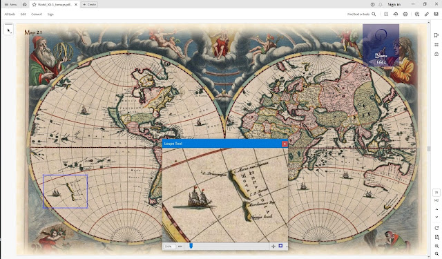
Loupe
Use the loupe tool for checking place names etc. (The image resolution of most maps is adequate for reading purposes.)
Navigate
Move backward and forward to previous views. In this way maps from different periods can be easily compared.
Pan & zoom
Use the zoom & pan window to view geographic features
Print
Print a selection of maps plus their descriptions
Rotate
If necessary, individual maps can be rotated to a standard North orientation. (In ancient times the top of a map was often facing towards a different direction than is common today.)
View
Adjust the standard way pages are displayed. E.g. a common option is '2 pages up' so that both the map and its description are visible on the screen.
etc.
Add bookmarks and/or jump to existing ones
Find/Search
Use keywords for finding maps of a particular author, year, map number (index) etc.
Loupe
Use the loupe tool for checking place names etc. (The image resolution of most maps is adequate for reading purposes.)
Navigate
Move backward and forward to previous views. In this way maps from different periods can be easily compared.
Pan & zoom
Use the zoom & pan window to view geographic features
Print a selection of maps plus their descriptions
Rotate
If necessary, individual maps can be rotated to a standard North orientation. (In ancient times the top of a map was often facing towards a different direction than is common today.)
View
Adjust the standard way pages are displayed. E.g. a common option is '2 pages up' so that both the map and its description are visible on the screen.
etc.
*NOTE: If required, visit the website of Adobe to get a free and up to date version of Acrobat Reader.
